Benutzer:Inflec/Übersetzungswerkstatt/Norwood Tunnel
Schon Übersetzt
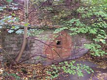
[Bearbeiten | Quelltext bearbeiten]Der Norwood Tunnel war ein 2,637 m langer, , 2.82 m breiter und 3.7 m hoher Ziegelsteintunnel. Er verlief entlang des Chesterfield Canals. Sein westlicher Eingang befindet sich in Norwood, sein östlicher in Kiveton, South Yorkshire, England.[1]. Insgesammt wurden um die 3 Millionen Ziegelsteine verbaut.[2]
Ursprung
[Bearbeiten | Quelltext bearbeiten]Der Kanal von Chesterfield's Parlament wurde 1771 übergeben. James Brindley war der Chef Ingenieur und John Varley war der ?Rennleiter? der Baustelle. Nach dem Tode James Brindley 1882 wurde John Varley zum ?acting? Chef Ingenieur befördert, und musste die Arbeiten alleine anführen. 1774 wurde dann Hugh Henschall, James Brindley's Schwager, zum Chef Ingeniur befördert. Er arbeitete nun mit John Varley, welcher nun ?Bewohner? Ingenieur war, zusammen, um den Bau zu vollenden.
Hugh Henschall bemerkte später, dass Teile des Norwood Tunnels minderwertig waren, John Varley vermied es aber die Schuld zu vermeiden.
Der Norwood Tunnel wurde am 9.Mai.1775 eröffnet und hielt zu dieser Zeit den Rekord als Englands längster Kanaltunnel gemeinsam mit James Brindleys Harecastle Tunnel.[3]
noch zu übersetzen
[Bearbeiten | Quelltext bearbeiten]The Norwood Tunnel forms a large part of the summit pound of the canal, with Norwood Locks descending from the Western Portal and Thorpe Locks descending to the East of the Eastern Portal.
The tunnel does not have a towpath, therefore the narrowboats were pushed through the tunnel by their crews. This process of pushing against the walls or roof of a canal tunnel with one's legs in order to propel the narrowboat through the tunnel is called Legging.
Decline
[Bearbeiten | Quelltext bearbeiten]The Manchester, Sheffield and Lincolnshire Railway (MSLR) purchased the Chesterfield Canal in 1847. In order to accommodate its railway line the tunnel was (according to some sources and rejected by others) lengthened to 3102 yards (measuring the distance on a map suggests the tunnel was not extended).
After days of heavy rain a 12–14 yard section of the tunnel collapsed on 18 October 1907, leaving a large hole in a field near the road to Harthill. With only minimal boat-traffic on the declining canal the cost of repairing the fall could not be justified and the tunnel has remained blocked ever since, splitting the Chesterfield Canal into two sections.
The tunnel today
[Bearbeiten | Quelltext bearbeiten]
The Chesterfield Canal has been restored as far as the Eastern Portal of the Norwood Tunnel largely through the efforts of Chesterfield Canal Trust. Part of the canal West of the tunnel from Chesterfield to Staveley has also been restored. Further restoration is proceeding. Current plans for the tunnel include the opening up of the tunnel in the Kiveton Park area, creating a cutting followed by the restoration of the remaining tunnel to Norwood.
| Portal | Coordinates |
|---|---|
| Eastern | Koordinaten fehlen! Hilf mit. |
| Mid-point | Koordinaten fehlen! Hilf mit. |
| Western | Koordinaten fehlen! Hilf mit. |
See also
[Bearbeiten | Quelltext bearbeiten]References
[Bearbeiten | Quelltext bearbeiten]Notes
[Bearbeiten | Quelltext bearbeiten]Bibliography
[Bearbeiten | Quelltext bearbeiten]- Henry Rodolph De Salis: Bradshaw's Canals and Navigable Rivers. David & Charles, 1969, ISBN 0-7153-4689-X.
- John Farey: General View of the Agriculture and Minerals of Derbyshire. 1811.
External links
[Bearbeiten | Quelltext bearbeiten]- British Waterways Archives.
- Chesterfield Canal Trust History.
- The World's Longest Navigation Canal Tunnels.
- Jim Shead: Canal Tunnels in the United Kingdom.
[[Category:Canal tunnels in England]]