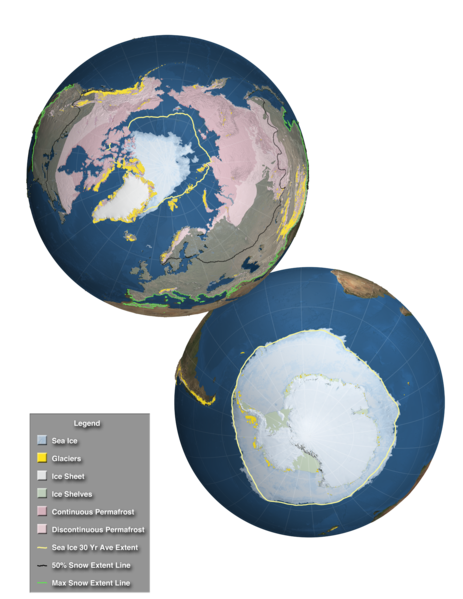
Datei:Components of the Cryosphere.tif
Zur Navigation springen
Zur Suche springen

Größe der PNG-Vorschau dieser TIF-Datei: 463 × 599 Pixel. Weitere Auflösungen: 185 × 240 Pixel | 371 × 480 Pixel | 593 × 768 Pixel | 791 × 1.024 Pixel | 2.048 × 2.650 Pixel
Originaldatei (2.048 × 2.650 Pixel, Dateigröße: 20,91 MB, MIME-Typ: image/tiff)
Dateiversionen
Klicke auf einen Zeitpunkt, um diese Version zu laden.
| Version vom | Vorschaubild | Maße | Benutzer | Kommentar | |
|---|---|---|---|---|---|
| aktuell | 15:22, 3. Dez. 2013 |  | 2.048 × 2.650 (20,91 MB) | Originalwana | {{Information |Description ={{en|1=This high resolution image, designed for the Fifth Assessment Report of the Intergovernmental Panel on Climate Change, shows the extent of the regions affected by components of the cryosphere around the world. Over... |
Dateiverwendung
Die folgende Seite verwendet diese Datei:
Globale Dateiverwendung
Die nachfolgenden anderen Wikis verwenden diese Datei:
- Verwendung auf azb.wikipedia.org
- Verwendung auf es.wikipedia.org
- Verwendung auf eu.wikipedia.org
- Verwendung auf fr.wiktionary.org
- Verwendung auf he.wikipedia.org
- Verwendung auf hi.wikipedia.org
- Verwendung auf hu.wikipedia.org
- Verwendung auf ja.wikipedia.org
- Verwendung auf ky.wikipedia.org
- Verwendung auf la.wikipedia.org
- Verwendung auf sr.wikipedia.org
- Verwendung auf sv.wikipedia.org
- Verwendung auf th.wikipedia.org
- Verwendung auf vi.wikipedia.org
- Verwendung auf www.wikidata.org
- Verwendung auf zh-yue.wikipedia.org

