Datei:Micronesia and Marshall islands bathymetry.pdf
Zur Navigation springen
Zur Suche springen
Größe der JPG-Vorschau dieser PDF-Datei: 800 × 518 Pixel. Weitere Auflösungen: 320 × 207 Pixel | 640 × 415 Pixel | 1.024 × 663 Pixel | 1.280 × 829 Pixel | 2.560 × 1.658 Pixel | 8.231 × 5.331 Pixel
Originaldatei (8.231 × 5.331 Pixel, Dateigröße: 16,49 MB, MIME-Typ: application/pdf)
![]()
Diese Datei und die Informationen unter dem roten Trennstrich werden aus dem zentralen Medienarchiv Wikimedia Commons eingebunden.
![]()
Beschreibung
| Beschreibung |
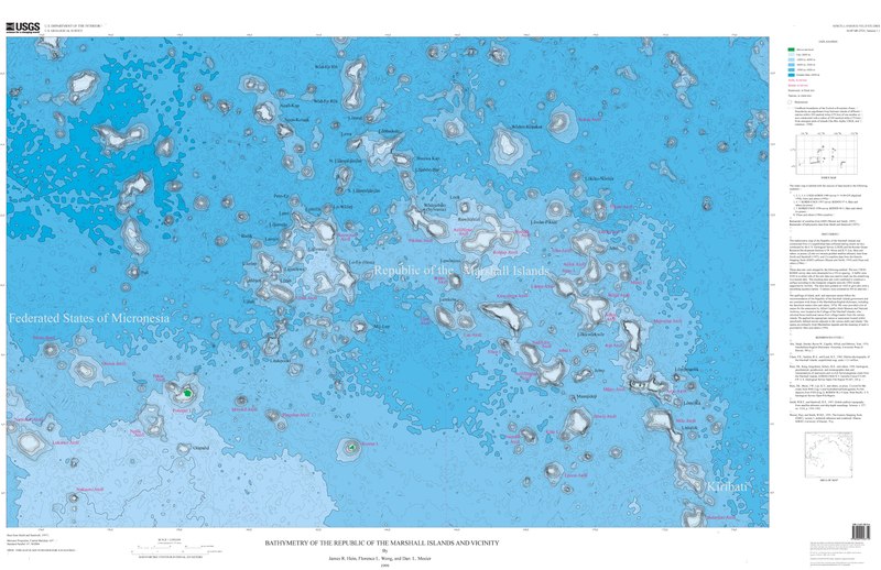
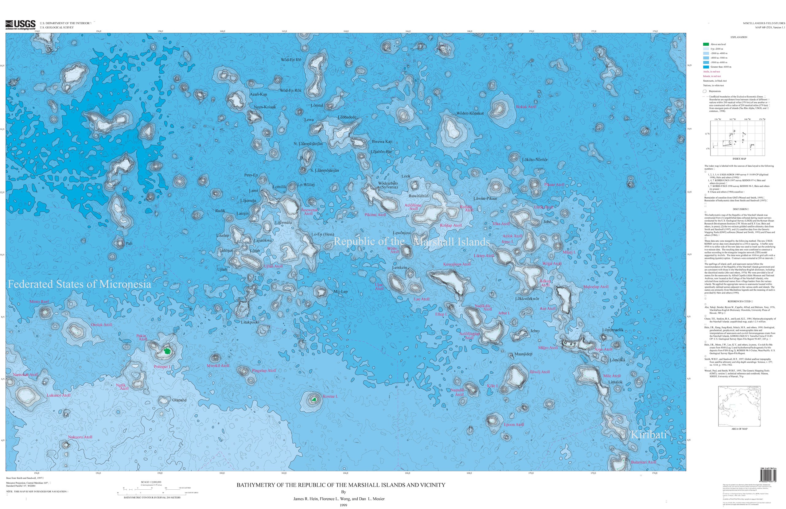
Français : Carte bathymétrique des monts sous-marins et des îles de Micronésie et des Îles Marshall. |
| Datum | |
| Quelle | https://ngmdb.usgs.gov/Prodesc/proddesc_33349.htm |
| Urheber | James R. Hein, Florence L. Wong, Dan L. Mosier |
Lizenz
Dieses Bild ist gemeinfrei (public domain), weil es Materialien beeinhaltet, die ursprünglich vom United States Geological Survey, einer Behörde des Innenministeriums der Vereinigten Staaten, stammen. Weitere Informationen finden Sie in den Urheberrechtsbestimmungen des USGS
|
Dateiversionen
Klicke auf einen Zeitpunkt, um diese Version zu laden.
| Version vom | Vorschaubild | Maße | Benutzer | Kommentar | |
|---|---|---|---|---|---|
| aktuell | 21:56, 17. Sep. 2019 |  | 8.231 × 5.331 (16,49 MB) | Sémhur | == {{int:filedesc}} == {{Information |Description = A bathymetric map of seamounts and islands in Micronesia and the Marshall Islands |Source = https://ngmdb.usgs.gov/Prodesc/proddesc_33349.htm |Date = 1999 |Author = James R. Hein, Florence L. Wong, Dan L. Mosier }} == {{int:license-header}} == {{PD-USGov-USGS}} Category:Geography of the Marshall Islands Category:Geography of the Federated States of Micronesia |
Dateiverwendung
Die folgende Seite verwendet diese Datei:
Globale Dateiverwendung
Die nachfolgenden anderen Wikis verwenden diese Datei:
- Verwendung auf en.wikipedia.org
- Verwendung auf fr.wikipedia.org
- Verwendung auf ru.wikipedia.org