Inott Point
Zur Navigation springen
Zur Suche springen
| Inott Point | ||
 Blick von Half Moon Island auf den Kubrat Knoll (links) und den Inott Point (rechts) | ||
| Geographische Lage | ||
| Koordinaten | 62° 32′ S, 60° 0′ W | |
| Lage | Livingston-Insel (Südliche Shetlandinseln) | |
| Gewässer | McFarlane Strait | |
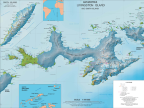
 Karte der Livingston-Insel (Mitte) mit dem Inott Point (rechts) | ||
Der Inott Point ist eine Landspitze an der Ostküste der Livingston-Insel im Archipel der Südlichen Shetlandinseln. Sie liegt 1,5 km nordnordöstlich des Edinburgh Hill und ragt in die McFarlane Strait hinein.
Das UK Antarctic Place-Names Committee benannte sie 1962 nach Robert Inott (1764–1825), Kapitän des Robbenfängers Samuel aus Nantucket, der zwischen 1820 und 1821 in den Gewässern um die Südlichen Shetlandinseln operiert hatte.
Weblinks
[Bearbeiten | Quelltext bearbeiten]- Inott Point. In: Geographic Names Information System. United States Geological Survey, United States Department of the Interior, archiviert vom (englisch).
- Inott Point auf geographic.org (englisch)
